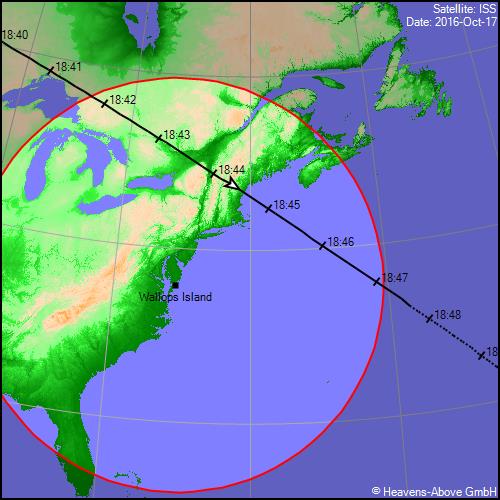
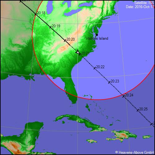
ISS Ground Track Maps for October 17, 2016, from Heavens-Above,
compared to an OA-5 Launch Track Map
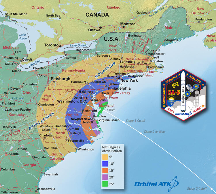
I observed this launch from Borton Landing Rd in Moorestown, NJ, which is approximately at the right edge of the bowl in the initial "P" in Philadelphia on the OA-5 map. That would put it just above the border between the 10° and 15° zones. Using my outstretched hand as a reference (the nominal 25° between the spread tips of my thumb and pinky) and comparing that to the spot where the glowing rocket exhaust reached its maximum height as it passed some guy wires on a nearby antenna tower, the Antares rocket reached an altitude just under 20°, a little higher than the Orbital ATK map suggests.
___________________________
The following is the launch report I posted on several e-groups:
I ended up at Borton Landing Rd in Moorestown, NJ, (152
miles from Wallops Island) to watch the Antares rocket launch earlier this
evening (October 17, 2016). My expectations for what
I might see were not that high, based on the modest altitude predicted for our
area, the fact that it was
heading away from us (towards Africa), and on top of that, sky transparency
didn't look that great.
I decided not to fool around with a camera and just used my
16x70 binoculars. I was pleasantly surprised to say the least. I had NASA TV
going on my smartphone and it was good to know that there was a 5-minute launch delay
to 7:45 pm EDT (I'm not sure why, but they were using Central Time, 6:45 pm, on
NASA TV). It was almost 7:46 pm by my watch (which I had checked against the NIST
web clock earlier) when the rocket took off on the video, and shortly after, I
noticed it a few degrees above the southern horizon. I'm guessing that the video
had a nominal 1-minute delay. If there was a real-time clock on the tiny screen,
I couldn't find it.
Anyway, to the unaided eye, the rocket exhaust looked like
a red dot, surprisingly similar to the red color of warning lights on the
numerous antennae in the area, so it stood out by it's movement. It also looked
red in the 16x70s, redder than any rocket exhaust I've seen before. As it rose,
the exhaust turned into an elongated plume. Quite impressive, but then it
disappeared into a cloud as it rose further while travelling from right to left.
Then after a minute or so, a bright whitish dot appeared abruptly on the
imaginary extension of the original path through the cloud. Looking back at the
trajectory maps, it may not have disappeared entirely due to a cloud, it might
have been the lull between the first stage cutoff and second stage ignition.
By then, it was no longer rising — I guess it reached a
peak close to 20° altitude. Regardless, the whitish second stage plume was
really exquisite in the 16x70s with multiple, various intensity straight and
curving streams trailing the vehicle (the vehicle itself was not visible). I
continued to follow it's apparent motion to the left as it actually headed away
to the southeast. Then a guy pulled up and started asking what everybody was
looking at (there were probably eight or so cars parked along that stretch of Borton Landing Rd
from people watching the launch). While blabbing away with him, I lost track of the dimming
dot in the southeast.